Belem Airport Guide: Flying Into the Mouth of the Amazon
Belem Airport links the Amazon delta with Brazil and beyond. Read about its wartime origins, two runways, airlines, routes, transport and spotting.
 By The Aviation Hub
5 min read
Updated October 20, 2026
Belem sits where the Amazon system meets the Atlantic, and for much of northern Brazil the quickest way in or out is by air. Belem Airport, officially Val de Cans/Júlio Cezar Ribeiro International Airport, handled just over four million passengers in 2025. That was a sharp rise, helped by the city hosting the COP30 climate summit in November. The airport serves the capital of Pará State and acts as a feeder for remote towns across the eastern Amazon.
Belem Airport at a Glance
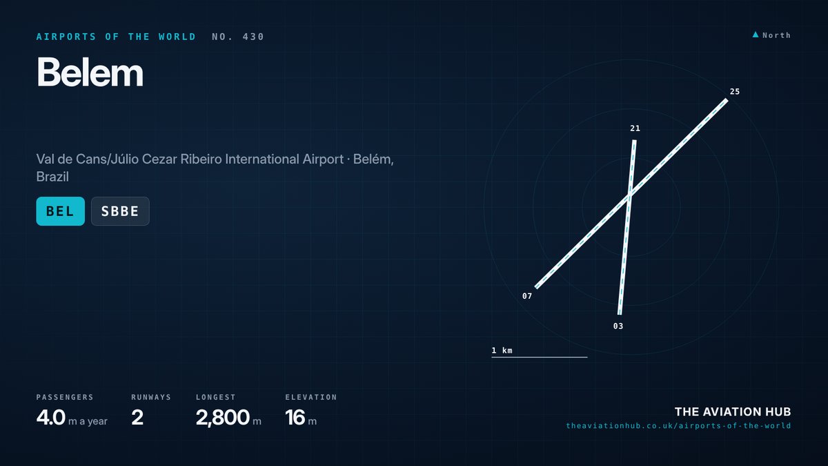
The IATA code is BEL and the ICAO code is SBBE. Belem Airport lies in the Val de Cans district, about 7 miles (12 km) from downtown Belem, close to the shore of Guajará Bay. The elevation is 54 feet (16 metres). There are two runways and one passenger terminal, and the Brazilian Air Force shares the site.
Traffic reached about 4.0 million passengers in 2025, up from roughly 3.3 million in 2024, with nearly 32,000 aircraft movements. LATAM, Gol and Azul carry most passengers. In 2022 the Novo Norte consortium won a 30 year concession to run the field, ending nearly five decades of operation by state operator Infraero. Information appears on the airport’s official website.
How Belem’s Airport Came to Be
The search for a site began in 1934, when Val de Cans was little more than a 1,200 metre strip of cleared land. The Second World War transformed it. United States forces built runways here for the Air Transport Command, which ferried aircraft and supplies via Brazil towards Africa and the European theatres. The airstrips passed back to Brazil’s Ministry of Aeronautics in 1945.
Airlines such as Panair do Brasil and Pan American were early users. The first passenger terminal opened on 24 January 1959. Infraero took over in 1974 and ran Belem Airport for almost half a century.
A new terminal opened in 1999 beside the old one, which was later demolished so the new building could be extended. On 13 April 2010 the airport took the name of Júlio Cezar Ribeiro de Souza, a nineteenth century Pará researcher who experimented with balloons and airships.
Runways at Belem Airport
The main runway, 07/25, measures 2,800 metres (9,186 feet) long and 45 metres (148 feet) wide. The secondary runway, 03/21, is 1,830 metres (6,004 feet) long and also 45 metres wide. Both are asphalt. The main runway comfortably handles narrow body jets such as the Airbus A320neo and Boeing 737 MAX 8, as well as long haul twins on medium sectors.
Northeasterly trade winds often favour runway 07. Runway 25 comes into use when winds shift during storms. The secondary runway serves crosswind days, light aircraft and some military movements.
Weather is the defining factor. Belem sits close to the equator and is famous for its rain, with heavy afternoon downpours almost daily in the wet season. Thunderstorms can delay arrivals for short periods, but the field rarely closes for long.
Terminals and Airlines
The single terminal was extended after the old building came down, adding six jet bridges. Upgrades ahead of COP30 refreshed parts of the building. Domestic flights dominate, with a smaller international area. The Brazilian Air Force base occupies part of Belem Airport, bringing military transports and helicopters into the mix.
LATAM, Gol and Azul all fly here. LATAM and Gol focus on trunk routes to Brasilia and Sao Paulo, while Azul connects via its Campinas hub and runs regional services into the interior of Pará. Smaller regional operators serve river towns that have no road link to the coast. TAP Air Portugal has linked Belem with Lisbon, giving the city a direct route to Europe. Alliance coverage is limited, although TAP and Azul have close commercial ties.
Routes and Destinations
Brasilia and Sao Paulo are the core domestic routes, with several daily flights from the main carriers. Rio de Janeiro, Recife, Fortaleza and Manaus add further links. Regional flights fan out to Santarém, Marabá, Altamira and other cities in Pará, many of them hours away by river.
Lisbon, about 3,700 miles (6,000 km) away, has been the main international route. Air France flies to Cayenne in French Guiana, while Gol and Surinam Airways serve Paramaribo. Avianca links Belem with Bogota, and Gol has served Miami, with flights scheduled until January 2027. Traffic peaks during the July school holidays and around the Círio de Nazaré festival in October, one of the largest religious processions in Brazil.
Cargo matters too. Fish, fruit and other goods from the Amazon leave in the holds of passenger aircraft and on freighters.
Getting to and from Belem Airport
Most travellers use taxis or app based rides. The trip downtown takes around 20 to 30 minutes, longer at rush hour or in a storm. Avenida Júlio César links the terminal with the city’s main roads.
City buses serve the airport road and are the cheapest option, though they can be crowded and slow with luggage. For most visitors a ride hailing car is the cheapest sensible choice. There is no rail link. Parking sits in front of the terminal, and car hire desks operate in arrivals. Boats to Marajó Island and river cruises leave from the waterfront, a short drive away.
Spotting and Photography
Belem Airport offers a mix of Brazilian airliners, regional turboprops and military aircraft. Public roads around the perimeter give some views of runway 07 approaches, which come in from the southwest. The terminal also offers views of the apron for passengers.
Close to the equator, the sun passes high overhead, so mornings and late afternoons give the best light. Afternoon storms often clear the air, leaving sharp conditions in their wake.
The air force base makes security tight. Stay on public land, keep away from fences and military areas, and follow any instruction from security staff.
What Comes Next
The concession requires investment in the terminal and airside facilities over its 30 year term. COP30 brought upgrades and international attention, and the operator will hope to turn that into lasting route growth. Belem Airport could become a stronger gateway for Amazon tourism and for links to Europe and the Caribbean.
Environmental scrutiny will grow, given the region’s importance for climate. Compare the field with other Brazilian airports on our Airports of the World map. The verdict: Belem Airport has the runways and a fresh operator, and its next step depends on turning post COP30 attention into new routes.
Continue to follow The Aviation Hub for more analysis and insight.
Advertise with us Your brand, in front of an aviation audience Home page and in-article placements, sold directly, one advertiser per slot. From £250 a year. See the rates